Sabin, 24751 & 44491; Hill (2), 612 ; Howgego, M-43; Lada-Mocarski, 54 ; see Odile Gannier, Consigner l’événement : les journaux de voyage de Marchand, in “Annales historiques de la Révolution française”, n° 320 (2000).
First edition, the rare in 4to issue.
Account of the second great circumnavigation voyage by a Frenchman, a quarter of a century after that of Bougainville, “a very important and authoritative work for the history of the northwest coast” (Lada-Mocarski).
The work was based on the notes and logbook of Étienne Marchand (who died in 1793) by Charles-Pierre Claret de Fleurieu (1737-1810). Other sources were incorporated into the final version: the report sent from the Ile de France in April 1792, the diary of the ship’s surgeon Claude Roblet and, above all, the diary of Captain Prosper Chenal, second in command, who was in charge of all the reconnaissance work during the expedition. The Solide’s mission, launched by private shipowners, was originally purely commercial: to explore the route taken by ships trading in skins between Nootka and Macao. Marchand left Marseille on 14 December 1790; his return, on 14 August 1792, went unnoticed due to current political events (four days after the events of 10 August).
Although a commercial failure, the voyage was a success from a navigational point of view – the journey was very fast – and from a geographical point of view: Marchand explored the southern lands and discovered the islands of the northern Marquesas group (Ua Pou, Nuku Hiva, Motu Hiti, Eiao, Hotutu), which he aptly named the “Isles de la Révolution”.
“Parti de Marseille en décembre [1790] sur le Solide, il doubla le Cap Horn et reconnut en détail l’archipel des Marquises (Nuku-Hiva, Fatu-Hiva, Hiva-Oa, Vaitahu) qu’il baptisa îles de la Révolution. Grâce à lui le pavillon tricolore flotta pour la première fois dans le Pacifique (juin 1791). Il remonta ensuite vers le Nord, chargea en Alaska une cargaison de fourrures avec laquelle il gagna Macao après avoir fait escale aux îles Hawaï” (Taillemite).
“A most important work for the history of geographical discovery in the Northwest. Marchand’s expedition sailed around Cape Horn and, after touching at the Marquesas and Hawaii, visited Norfolk Sound, Queen Charlotte Island, Nootka Sound, and parts of the northwest coast of America, of which lenghty descriptions are given, in addition to descriptions of the Indian inhabitants. The introduction is a valuable feature of this work, as it contains Fleurieu’s learned researches on the early navigators to the North Pacific, from 1537 to 1791. Among others, the voyages of Drake, Juan de Fuca, Admiral de Fuentes (de Fonte), Bering, Chirikov, Cook, La Pérouse, Meares, Portlock and Dixon, Colnet, Don Haro, and Malaspina are discussed and recapitulation given. The second volume gives nautical observations and natural history… The third volume has more natural history, Drake’s discoveries of 1578, and Roggeveen’s voyage, 1721-22, as well as a ‘Liste générale des voyageurs et des auteurs cités…’ The fourth volume relates to hydrography and hydrographical charts (…), as well as copies of earlier charts and new surveys of the Marquesas Islands and the northwest coast of America” (Hill).
Claret de Fleurieu’s introduction is a veritable essay on the exploration of the North Pacific between 1537 and 1791, with historical and critical remarks on the voyages of Drake, Juan de Fuca, Admiral de Fuentes, Bering, Chirikov, Cook, La Pérouse, Meares, Portlock and Dixon, Colnett, Don Haro and Malaspina.
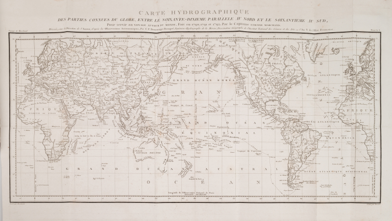
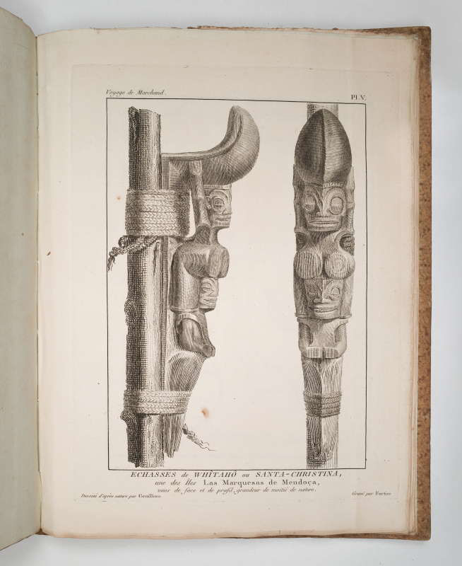
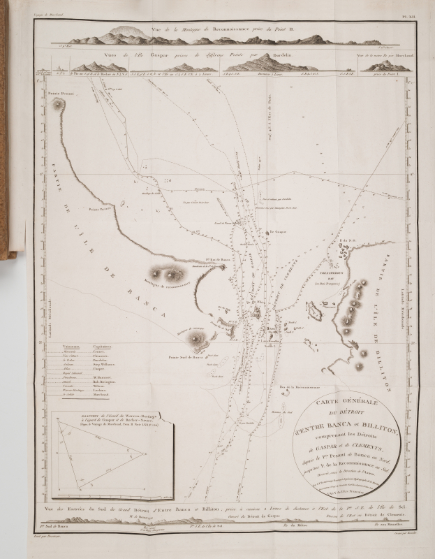
The illustration comprises 16 plates numbered I to XV (there is a plate VI bis), including 15 folding maps (engraved by Collin, Tardieu, Bouclet and D’Houdan), and a figure engraved by Fortier after Genillion (stilts of Santa-Christina, in the Marquesas).
Light waterstain on the inner corner of the atlas.
A fine copy, well preserved in its original publisher’s binding. Text and atlas with full margins, entirely uncut.